Tracks of the StoneBear Copyright MCMLXIII Uncle Hargus ALL Rights reserved
ROF= Ring of fire Odyssey MEF-H = Marine Expeditionary Force- Hargus
StoneBearTracks ROF/ CR = Costa Rica journey
Puntarenas, Costa Rica and the Pacific coast to Guanacaste
UofAla independent study Summer 1977
A stop for coffee before catching the bus to Puntarenas
On one of the last trips of the summer headed west to the Pacific port of Puntarenas. If this is anything like the last trip to the Pacific coast of Costa Rica... well... I'm prepared. I'm a seasoned Latin American traveler now. I'm ready for anything, ... which means that my expectations are for accommodations that would make a fish camp in the US equal to a Holiday Inn.
San Jose is a busy urban city. A lot of energy on the go.
Leave out of San Jose by 8 heading west. We're on THE same chartered bus again as there is no regular - dependable - public transportation service between the capitol, San Jose, and Puntarenas, the only Pacific coast seaport. That doesn't sound good. The main Pacific shipping trade port,... the main link to the shipping civilized world doesn't have regular public transportation. Ok... this is forming up to be a regular - the norm- adventure traveling through Latin America.
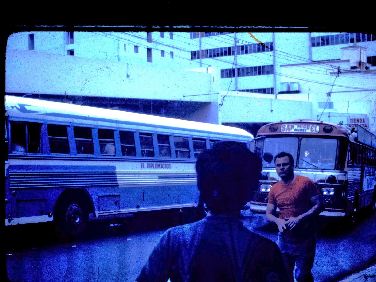
Central bus transit station San Jose. Public mass transit was really good in the city... regular bus routes every 15 to 30 minutes, dependable... and cheap!. I'd ride the bus from San Jose to Cartago for 1C - 1 Colon = .12 cents.
Each driver owned their bus and decorated their bus... most very unique and very festive. Most buses were named much like the WWII planes had "nose art"... ie... "El Toro Bravo" = The Fighting Bull... with a hand painted snorting bull on each side of the bus. They were a lot of fun to ride. You can actually see the front of the bus... at rush hour it was standing room only... ?60+ riders holding onto the upper rails.

Not so much in San Jose but out in Cartago and other small towns... this is how you bought a chicken... alive...with the feet tied up. Not many campesinos have fridge/ freezer so Tica moms shop at the market everyday for what they'll cook for the family that night. OFTEN I'd ride on buses that would have a Tica lady with her few groceries/ vegtables, and live chicken in her carry shopping bag. The bus hits a pothole,... the shock jars the chicken and they squawk, squawk 'til they settled down. Some buses also smelled like a barn. Most drivers kept them clean and had regular riders. Public/ mass transit in Latin America is very interesting.
Business storefront in San Jose.
Yes, there was a McDonalds in downtown San Jose... a favorite, frequented place to get an American burger is San Jose. A Big-Mac for $1.03, Papas Fritas = French Fries for $ .29 cents US... Oh, thank god for America; when you're a long way from home....after months of eating local greasy Arroz con Pollo and tortillas - which are good... there's nothing like a real
US hamburger!
Now I'm going to borrow a few paragraphs of description of road conditions from the Quepos post because it's similar roads/ travel :
****
As the crow flies Puntarenas looked about 50 miles west of San Jose. Just one problem, ... the Andes mountains are in between San Jose and Puntarenas and there is no straight road there. we'll have to take a charter bus that goes over the Andes mountains... the mountain chain that runs from Argentina to Alaska... on a road that gives real meaning to the phrase adventurous travel.
Looking at the map I thought about a 2+ hour distance... that was the direct line road map liniage calculation. Of course I wasn't thinking about going up and down the mountain passes of the Andes... also... the map shows a road Hwy 1 that looks the same as the Pan American Highway ... = to US interstates. It looked somewhat doable without much effort. Oh, but you forget,... I must be exhausted after months in Latin America, this is traveling in the 3rd world.
Left San Jose about 8 in the morning. The Latino hustle and bustle of the Capitol is unique as we head west out of town. You see all the uniquely individual decorated mass transit buses.
A lot of energy on the go.
Downtown San Jose.
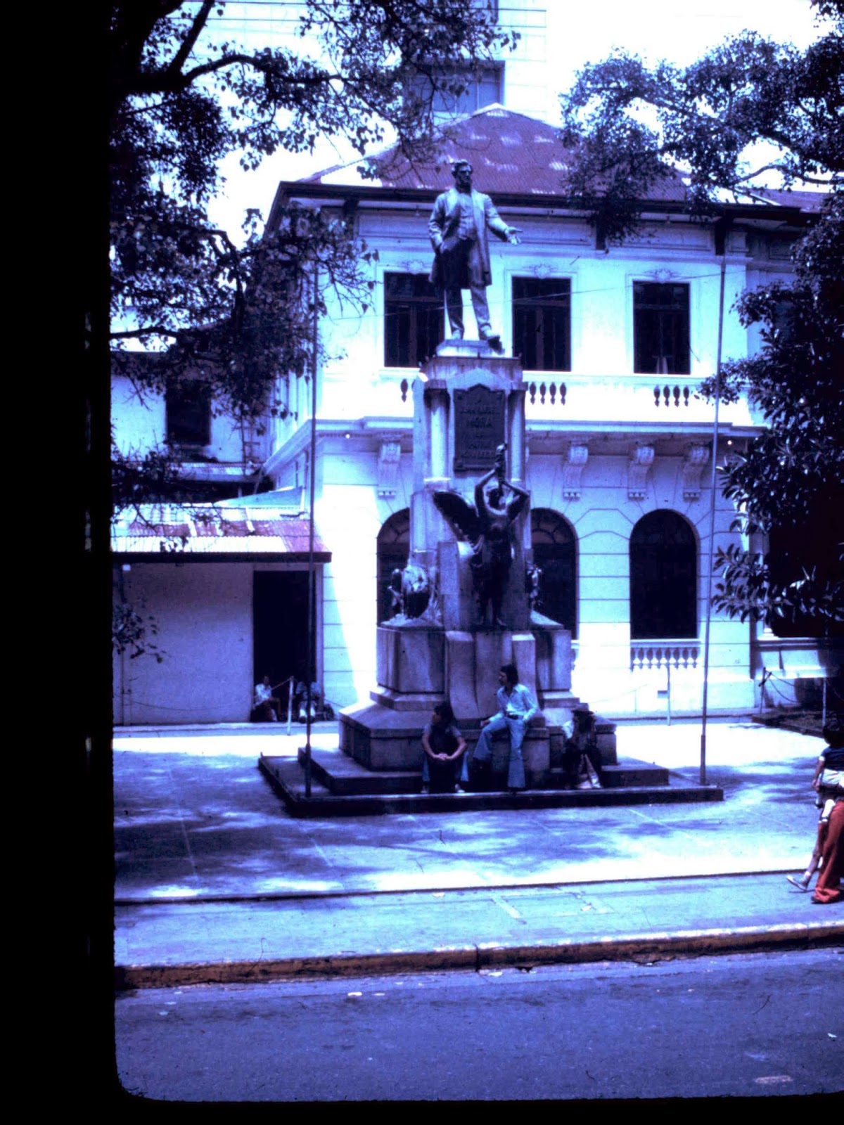
A lot of parks and monuments in San Jose.
At a central park in downtown San Jose... I think this is the monument celebrating Costa Rica independence. The wreath was placed the week before by visiting US President Jimmy Carter.
1977 UofAla student Susan Patterson in Costa Rica.
San Jose has a mass transit bus system that really does work great. I've ridden public transportation buses all summer and interlined/ changed buses/ connections and never had any serious delays. Although one time I would up with Susan in the natural springs resort town of Orosi by wrong translation.
An industrial warehouse district in San Jose. Maybe the main carniceria... butcher shop / beef supply.
Beef hind quarters being delivered to mercado carnicerias... butcher shops.
This is a charter bus as there is no regular transit bus to Puntarenas. In the first 10 miles we pass through small towns of La Garita and San Ramon,.... dirt roads..
Dirt roads are the standard and you can see some small potholes. some potholes are the size of a car and a bumpy foot deep. They will shake your teeth if going too fast, and tear the suspension out of a car in no time.
then it's wilderness, green, and I mean green nothing rain forest growth forever. It's Paved road since leaving San Jose but there are some stretches of dirt road.
?Did I say green? Some places you can't see 30' at ground level.
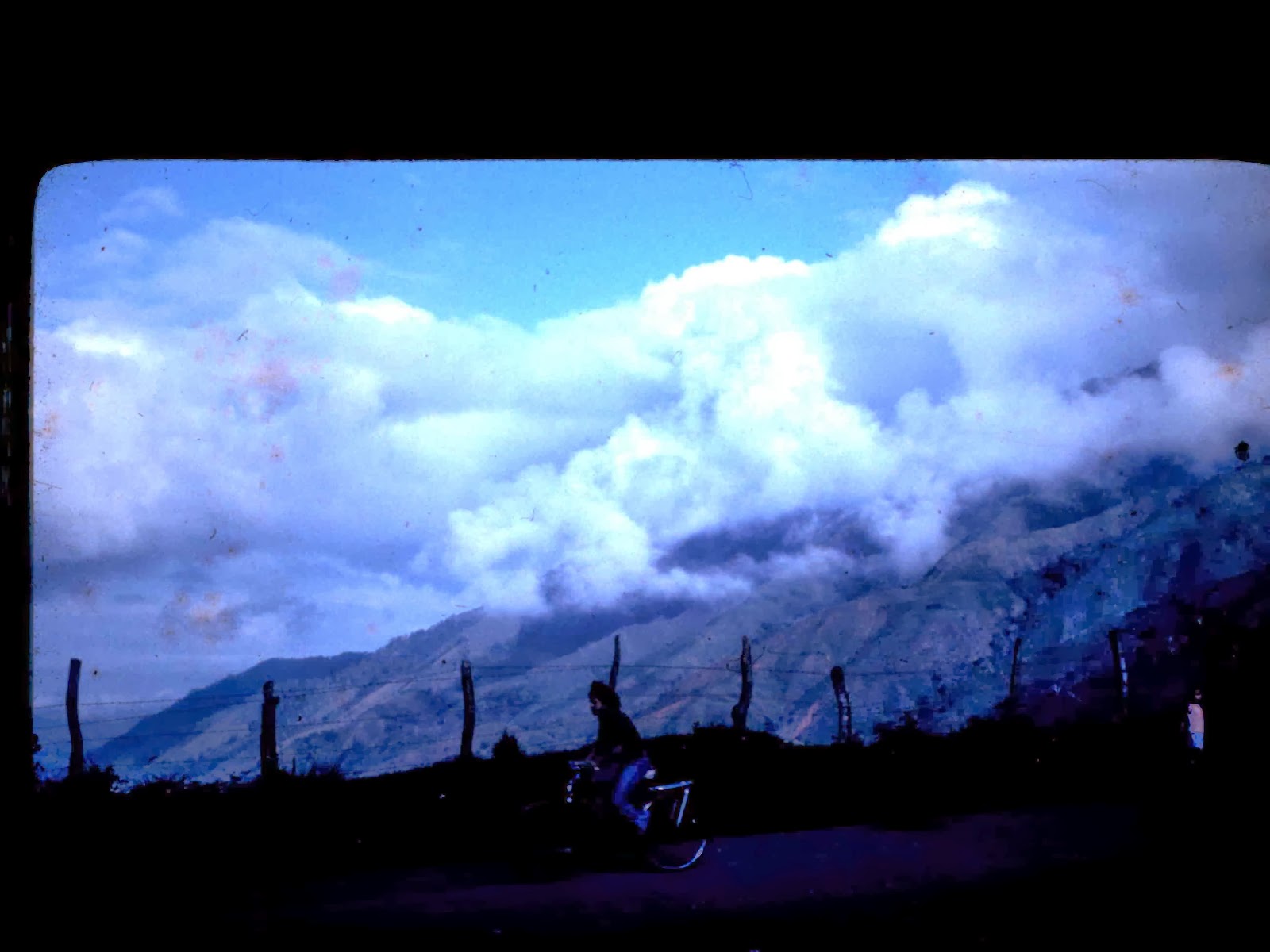
Heading due West now and am climbing/ inclining a general ascenion, then down into valleys / gaps, and switchbacking back up the next mountain. We were at 3,840' elev when we left San Jose. We're already getting up into cloud layers at times below mountain peaks.
Going over some of the mountain peaks the vista overlooks of the Costa Rica mountains and valleys are uninhabited pristine. The air is so thick and pure/ clean you feel like you gain a couple pounds when you breath in. We've got to be up 5,000'elev by now. the air is thinner, but clean and getting cooler.
The roads now have graduated to "mountain" status.... winding around mountain ledges, often narrowing down to one lane. NO guardrails on mountainside cliffs. A couple places you could see a rusted out old car or truck that went off the mountain cliff; no way to retrieve it/ tow it... and that's the ones we could still see that the rain forrest jungle hadn't swallowed up under the vines and growth.
There are potholes on the paved part of the road that will shake your teeth unles you crawl through the hole at 5mph. On the dirt road sections there has been no road scraper on this road in several years. Some of the potholes are the size of the bus and a bumpy foot deep often with a mud puddle. Some mud ruts are a foot deep and we creep through slowly but with enough momentum to not get stuck. Some turns have a mud puddle 20+ feet wide. All while going up, then down on these curvy mountain switchbacks.
This road is so rough that the speed is 20 to 25 mph - tops ! It's almost like riding a horse it's so bumpy and rocking left and right. Hell, I think a horse would almost be better. Every incline up, then down through the bumpy road hazards is like riding an emotional roller coaster via the bus. You creep up the hill clink, clink, clink holding your breath, the bus just barely making it up, going over the crest,.... then want to scream on the downside. It's like our own personized... perpetual 20mph space mountain ride.
UofAla sociolgy students ?Debbie, Jan, and Liz... with luggage in the back of the bus.
Every now and then you'd see some form of a dwelling, shack, hut, ... some primitive living abode out in the middle of nowhere, but still a proud homeowner. I guess they live like they did decades ago. I saw several Costa Rican oxcarts and primitive cooking ovens on this trip.
A Tica lady walking out from her home.
One place we had to stop while a rancher moved his cattle herd across the road. That was maybe one of the more normal things that happened today.
Ascending up constantly we've got to be around 10,000'+ elev. Somewhere over in this range of peaks tops out about 11,500' elev. This bus with about 25 passengers is having a hernia getting up some of these hill climbs. ... and we come to a crawl. Steam is fogging up on the front wind shield; we're overheating. The driver stops the 1st place there is a wide enough spot.
We all get out to stretch while the driver has the hood up with steam pouring out. This is Latin America at it's best. We're on this road to hell... a hell dirt road hell of potholes and ruts. It's already past noon and we're nowhere near Puntarenas. Right now,... not even sure there is a Puntarenas with a beautiful Pacific coast ocean to swim in and walk on a nice warm sunny beach... the parade of that dream is being rainded on now- with dark clouds.
... and the driver hunts around for an empty coke can, goes over to the mud puddle in the curve, dips muddy water up and pours it into the radiator; no joke! Even the ladies knew not to do this; muddy water in a radiator to cool the engine. We are smack dab in the middle of NOwhere, I mean remote tropical rain forrest wilderness with NO traffic to speak of to rescue or send help. I'm beginning to sense what it felt like to be the last wagon at Donner Pass.
Liz, Jan, and ?Debbie? supressing and denying their fear of hillside cliffs with NO guardrail.
While waiting on the fate of the bus engine I took an unannounced group picture of the UofAla students. This is maybe the only group photo of the whole summer, and there are several students that were no on this trip to Quepos.
L to R: a tico kid sitting, tico in cowboy hat, Al, Alfredo Gutterrez, Becky from Mobile, Jody?, Steve Hough standing behind another Steve w/ beard and camera case, Dr. Selwyn Hollingsworth standing sideways, lady student 1?, lady student 2 ?Jan?, Bill? "Wolf" sitting, ?Louise? behind person on end in jeans.
Not pictured here; Dan Flynn, Toby?law school Toby?, Dr Richard Brough and wife ?Hazel?, Dr Edward Mosely, and there was another senior couple from ?Hattiesburg, Courtney "Coco" Glass was with us a few weeks then went on to Mexico for independent study. Susan Patterson. Bear w/ me for not remembering a name, this was 1977.
After about 30 minutes of cooling we load up and head out. A few more ups and downs but this has got to be the plateau and then we begin trending down... but there are still some more ups. We're on level flat roads now and actually going 30mph on some stretches. The engine is still over tasked; I wonder if the mud has clogged the thermostat?
We go through tiny hole in the wall places, crosroads of a couple of buildings, one a store. All remote run down nowhere places.
**********
Now this is the SAME charter bus and driver is why I included the text from another post. I had that sitting on the edge of the seat feeling the whole trip as you just knew that the engine was likely to sieze up/ burn up / burn out a main bearing ect.. at any mile. One of the girls said they never really put all her weight down on the seat she was holding her breath to whole trip.
But this is Costa Rica, Latin America in 1977... we've been here all Summer; ?What could possibly happen that would suprise us? ?Was there a travel nightmare from hell that we have not endured YET? We think NOT, but this trip is going to Puntarenas and then a week heading north along the Pacific beaches of Playa Carrillo, Playa del Sol, Playa del Lindo (I think this was just the name of a business), Tamarindo, Playa del Coco, then back via the cattle and ranching province of Guanacaste... returning to San Jose.
Small coastal village on the west, Pacific coast. All dirt roads.
Driving into Puntarenas.
It's about 2;30 and we're coming into Puntarenas. I'm excited. I always like port towns as they are a link to the bigger outside world and usually have a lot of interesting culture to offer.
The bus had about 20- 22 seats. Good window views.
Pulling into the town we were agahst. I have to refer back to a famous Marine Corps saying; "What a shithole!" Puntarenas is like the 3rd or 4th largest city in Costa Rica... THE Pacific shiping port. THE Pacific link to the capitol San Jose... NO Railroad train; couldn't get over the Andes!
The 2 story building on the left is a hotel and cafe.
Welcome to Puntarenas 1977.
The Carribean/ Atlantic/ gulf of mexico east Rail link to Limon ... there was no road; it was washed out and impassable often and undependable to plan travel on... or swamp land. That's why we took the jungle train to Limon. Also see that post:
Downtown Puntarenas 1977.
Puntarenas was all dirt roads/ streets. Some mud potholes were the size of the bus, some larger. If you didn't see any modern 1960s cars you would have thought Puntarenas was built in the 1920s to '30s and had never been repainted or any maintenance spent on it. There were cobbled together buildings of businesses, a few side streets had very modest looking residential homes. most was ramshackled together, typical Latin American 3rd world architechture; I just was expecting at least paved streets, but not suprised. It was hot, humid, and muggy even with some ocean breeze... remember, this is in a Gulf and the Pacific is still some 40 miles away. There were mosquitos here that could stand flat footed and honk a chicken.
A Puntarenas residential section with more modern homes. The huge palm trees were neat. This is the tropics. Dirt roads... the norm.
Getting close to the docks. Gulf of Nicoya on the left.
It's been 37 years ago so I forget. I think we stopped and got something to eat in the town, then went out to the port / docks to catch the ferry across the Gulf of Nicoya over to the Peninsula of Nicoya... then turn north and head up the Pacific coast.
It was late afternoon when boarding the Nicoyano ferry. It looked old and run down from all the patches of rust. the last orange paint was 10- maybe 15 years ago. I believe it was once one of the NYC ferrys to Staten Island, long since sold and now on duty in Puntarenas.
Loading the Nicoyano ferry at the dock.
A ship at the port docks looked like a freighter and I couldn't tell from the distance if it was loading or unloading. Everything looked old and worn out, the dock, the machinery equipment, hoists, smaller boats,... everything worn out.
A freighter in port... either loading or unloading?
While on the upper decks of the Nicoyano ferry took a few pix of some of the UofAla students.
While waiting at the upper starboard side railing looking out over the Gulf of Nicoya, watched a crop duster plane flying down the Gulf/ southest bound, at about eye level, and flew by about 50 yeards away. It looked like a Cessna ag plane, an agricultural sprayer - a crop duster- I could see the pilots face as he passed by.
This plane is about 30' above the water.
Becky from Mobile - middle - on the upper, open air deck of the Nicoyano heading west in the Gulf of Nicoya.
A ship coming into port on the Gulf of Nicoya. Afternoon cloud bank forming.
You could smell the Pacific salt air. Sunny, cool breez. From waiting to board, boarding, waiting more, transit across took about 40 minutes, waiting to unload, unload off shore was a good 2 hours. most things were slow in Costa Rica. To drive around would have taken a day,... or longer from horrible roads.
Now driving westbound across the Peninsula is ?Guess what?... ALL dirt roads again.
The roads now have graduated to "primitive 3rd world Latin America" status.... winding around hillside ledges, often narrowing down to one lane. NO guardrails on mountainside cliffs. A couple places you could see a rusted out old car or truck that went off the cliff curve; no way to retrieve it/ tow it... and that's the ones we could still see that the rain forrest jungle hadn't swallowed up under the vines and growth.
These are the Andes mountains that we went up and down. A 50- 60 mile drive took several hours. Paved road that has stretches on and off of dirt road. Then all dirt road for miles.
There are potholes on the paved part of the road that will shake your teeth unless you crawl through the hole at 2mph. On the dirt road sections there has been no road scraper on this road in several years. Some of the potholes are the size of the bus and a bumpy foot deep often with a mud puddle. Some mud ruts are a foot deep and we creep through slowly but with enough momentum to not get stuck. Some turns have a mud puddle 20+ feet wide. All while going up, then down on these curvy mountain switchbacks.
A small village somewhere in the Costa Rican mountains.
This road is so rough that the speed is 10 to 20 mph - tops ! It's almost like riding a horse it's so bumpy and rocking left and right. Hell, I think a horse would almost be better. Every incline up, then down through the bumpy road hazards is like riding an emotional roller coaster via the bus. You creep up the hill holding your breath, then want to scream on the downside. It's like a perpetual 20mph space mountain.
Every now and then you'd see some form of a dwelling, shack, hut, ... some primitive living abode out in the middle of nowhere. I guess they live like they did a thousand years ago. I saw several Costa Rican oxcarts and primitive cooking ovens on this trip.
These oxcarts were very common in the outback.
This Tico house had a wooden fence probably to protect the small garden.
Finally we hit the Pacific coast and started heading north on Hwy 160 driving with the ocean on the left side of the bus. And it was beautiful Pacific blue. sunny, warm, opened ever window on the bus for the ocean breeze.
I forget... this may be Playa del Lindo? Stayed there overnight. This open air cafe overlooks the ocean & wide black sand beach. That's the charter bus at the end of the parking lot.
I guess exhaustion was approaching over the next several days as I don't remember exactly how many towns / villages we stopped at... to eat and go on,... or to stop and stay the night. Bear w/ me it's 37 years ago but I do remember Playa del Lindo, Playa del Coco, and Tammarindo. Most were tiny Costa Rican Pacific ocean villages, ... a couple places modern enough to call itself a resort.
This was either a lunch stop cafe, or overnight lodging stay.
All dirt roads.
This is a cafe on the Pacific coast. Maybe they make deliveries on the motorbike?
These were all black sand beaches from the volcanic rock erosion. they were a different kind of scenic to walk on. Some of the beaches were a couple mile long and refreshing to take morning and evening hikes. it helped to have a little beachcomer in your blood.
This Tamarind seed is one of the few keep sakes from that journey. It's been on my keyboard for several years since writing this blog. Just seeing it triggers the fond memories of Costa Rica. When I hold that Tamarind seed in my hand and close my eyes I can almost smell pure clean Pacific ocean air and see beautiful ladies.
Black sand beach Pacific coast.
There were beaches that were scenic from all the boats at anchor in the harbor coves offshore. some nice looking yachts but most looked as permanent lived in vagabond ex-pat sailors. Some looked like they been at anchor here for a while, some looked as they were stopping for a few days? ... a few weeks or months? before heading to the next port.
Beautiful, refreshing morning walk on this beach.
This tri-hull catamaran was up on blocks on the beach... ?for repairs?
Black sand beaches. Pacific surf. This was a good 2 mile walk for a beachcomber. Very peaceful.
One of the mom and pop cafes had some cages outside with several parrots and beautiful colored birds.
Becky from Mobile feeds one of several beautiful birds/ parrots at a cafe stop.
At one of the resorts it had a beautiful thatched roof over an outdoor pavillion. Only a few more tourists were there beside us. It looked like a really fun place. It had a modern - clean - swimming pool and clean bathrooms. I was so used to taking beach baths. I got cleaner in the ocean than I did in a Costa Rican shower; a cold water pipe in a dark, grungy, bug infested, mildew smell shower stall with no, or a sticky curtain. But there were HOT showers here!
Cortez we have arrived at civilization. A real "Resort" on the pacific coast. In the summer of 1977 I had maybe a dozen hot showers; the regular was cold.... and I mean cold. Many places had this shower head with 2 wires... a heating element... that at best produced a weak luke warm water... enough heat that you didn't shiver in a shower. So this place was back to civilization with hot showers!
Under the thatched roof, this cafe pavillion was a treat!
Open air cafe at the beach.
Another open air cafe/ pavilion/ restaurant/ bar. This one was decorated and fun hangout at night.
The Ticos/ Ticas, the Costa Rican people were always nice to us and very acommodating and friendly. They didn't try to hustle us as we were broke college students staying in the economy rooms and they knew we had little to spend. Some of the regular tourists we met had similar stories of always something being overcharged, or price included then never delivered; they would tell regular tourists anything they wanted to hear to get the sale. Sometimes I observed... I think they didn't even understand the english spoken,... they just smiled and nodded to the tourists.
Big open air cafe had a large open space for dances.
The hawkers selling trinkets we'd say quando questo= ?how much? They'd give us a price and you could haggle a little. "Muey Caro" = too much and start to walk away and they'd give you a better price... and everything was so cheap it was still a bargain even when you paid too much; but they got the sale/ and were happy for the business.
The open air cafes near the ocean were neat... and didn't have many mosquitos. At lunch UofAla students talk with Dr Selwyn Hollingsworth.
One of the things I observed from the Puntarenas journey... I know this is 3rd world Latin America... but there is no law here. Very little police presence and very thin/ spread out. If you had a criminal mind to say... smuggle contraband... this was the wild west. I met and observed several people that fit the saying; A sunny place for shady characters. Most Ticos were hand to mouth existence, the Tico campesinos were peasants. I did eat in a piano bar that was suposedly frequented by Robert Vesco, an American wheeler dealer that embezzled about US $200 million in the US and headed for Costa Rica. My thoughts were that a lot of that went on here.
Heading back through Guanacaste province it was mostly flat, very hot, fields/ pastures of grass for cattle graising. Beef must have made a good living as the houses/ ranch houses looked more modern and mainstreamed normal... not shantys, huts but nice masonry villas. There was plenty of beef cattle but of the couple of steaks I ate, they were tough cuts/ flank steak; nothing like a US steak.
The Nicaragua border was about 20+ miles to the north and I've read this area was used to supply "the Contras" in an ugly internal war of leftist peasants and right wing authoritarian leaders and death squads. ?How could a beautiful country in Latin America become the place of ugly war and killing? After much Latin American study, it's a complex answer that touches many social, political factions and cultures... the land, who owns it/ who doesn't own it... I was fortunate to see it, breath it, live it in the Summer of 1977 in Costa Rica; I understand how... but can't explain it in less than a book.

This graffiti looked interesting when I saw this . Alfredo translated it and I understood not just the meaning, but saw the people in this culture that believed this by living in a Latin American government. .... And this is Costa Rica,. the most progressive of Latin America. In the other Latin American countries they become revolutionaries and form opposition militia. The graffiti translates - paraphrased- "The sindicate, meaning the unions or co-ops, are your strength; use them/ arm yourself. " After living in Costa Rica during the Summer of 1977,... you understand what can't be translated in this, or all these pictures.
You observe too many times the strange impromptu inconviences... that is not available, restrictions... that is for members, the "permits"... the bus driver needed to buy "a transit permit" for the tourists on the bus and it just so happens that the man collecting the "transit permit" fee is the brother-in-law of the policeman, or mayor; All these instances are resolved with a handshake with money changing hands. Glad I got to see this first person. To see and understand the universality of greed, poverty, corruption, cultures, ect... You really understand how the world works when you're at a checkpoint or border crossing.
StoneBear AKA Uncle Hargus Smoking a "Pintor" Costa Rican Cigar Summer 1977.
Latin American culture is wonderful,... exhilarating,... not for the faint of heart. Traveling on a journey with just a pair of jeans, my US Marine Corps Sgt Hargus khaki shirt, and a shoulder bag in the Summer of 1977,.... the only way to go; god I do love it so. Costa Rica was paradise.
You never drink twice from the same stream.
StoneBearTracks Copyright Uncle Hargus MCMLXIII ALL blog posts/photographs/video ALL Rights reserved
ALL Blog posts/photographs/video Copyright MCMLXIII ALL Rights Reserved


 Above the clouds in the Costa Rican Andes.
 Beautiful overlooks in the Costa Rican Andes.

 A brief stop for cattle crossing the road.
 The view from hotel "Maunuel Antonio cabins" lodging. All dirt roads.
 Quepos, Costa Rica 1977. Streets are dirt roads. A sheet in a window. ... before crime.
 Quepos, Costa Rica beach/ cove.
 Most of the beaches were black sand on the Pacific coast.


 Coraz'on Loco in the Pacific Quepos surf.